The lagoon was not empty and uninhabited when the Lombards arrived in Italy, and pushed the Byzantine aligned Venetians into the coastal areas.
We know that when Attila and the Huns sacked Aquileia in 452, the bishop and many of the residents fled to Grado in the nearby lagoon, which they fortified. In later documents, Grado is often referred to as a castrum — a castle or a fortress.
The town of Grado must therefore have existed before 452, even if it was just a small coastal village associate with the much more important Aquileia.
In the letter from Cassiodorus to the Tribunes of the Maritimes — usually dated to September 537 — there’s no mention of any notable towns or cities in the lagoons, but there must have been some identifiable settlements, both for the bearer of the letter to find the tribunes, and for the tribunes, as figures of authority, to govern the surrounding area.
The lagoon was not empty and uninhabited, and the people leaving the mainland didn’t flee the invaders to go and live in mud huts in the marshes.
The lagoons after the Lombards
The first record we have, after Cassiodorus, are all church records of various kinds, often related to some of the bishops of Venetia asking permission of the Pope to move the see of a bishopric to a town in the lagoon areas.
Patriarch Paulinus of Aquileia moved to Grado, which had already been fortified during the times of the invasion of the Huns in the mid-400s, in 568, at the time of the Lombard invasion.
He did not seek the permission of the Pope, as they were on opposite sides of the Schism of the Three Chapters.
The bishop of Concordia relocated to Caorle, probably in 616, and received permission from Pope Adeodatus I for the move.
The see of Opitergium (Oderzo) moved to Eraclea in a now lost lagoon area north of the Venetian lagoon, and the diocese Altinus relocated to Torcello, some 15km north of Venice. Both of these transfers happened in 640, or shortly before, as they were sanctioned by Pope Severinus, who only reigned for 66 days that year.
Clearly, the towns of Grado, Caorle, Eraclea and Torcello were already sufficiently well-established to be the seats of bishoprics, even if it was probably perceived as temporary at the time. In face, none of the dioceses changed their name, so nominally — at least for a while — they remained attached to the original location.
Besides these church related notices, we have very few sources about the early lagoon settlements, and nothing for several centuries.
We have three charters from the Holy Roman Empire, which contain in the provisions also lists of Venetian settlements. They are respectively from 840, under emperor Lothair I, from 967, under Otto I, and from 983, under Otto II.
Next, we have a part of a manual for governing the Roman Empire. The Byzantine emperor Constantine VII Porphyrogenitus wrote a manual for his son about how to administer the empire, called appropriately De Administrando Imperio, from around 950. Part of this treatise is a geographical description of all the provinces and territories, which include the land of the Venetians.
Third, we have the first Venetian source available, which is the Istoria Veneticorum by John the Deacon, from around the year 1000, where a short section names the main settlements of the Dogado.
Finally, book three of the Chronicon Altinate has some information about the lagoon environment, some of the settlements, and how it was organised, but probably from a later period, and large parts of it seem rather apocryphal.
The Istoria Veneticorum
The Istoria Veneticorum, by John the Deacon, is the earliest Venetian source we have for this.
As part of the narrative of the Lombard invasion, and the migration into the lagoons, he lists all the main settlements.
Here’s the description of John the Deacon, starting in the north, moving southwards through the lagoons:
Now, indeed it is necessary to properly express the names of the individual islands.
The first is called Grado, which possesses high walls and churches richly decorated and full of the bodies of saints, and just as Aquileia was in ancient Venetia, so it is recognised that this [place] will be the head and metropolitan see of all the new Venetia.
The second island is called Bibione.
The third, however, is called Caorle, to which the bishop of Concordia, arriving there with his companions. terrified by fear of the Lombards, with the authority of Pope Adeusdatus, confirmed that his episcopal see would remain there in the future and decided to dwell there.
The fourth island, on which long ago a city had been built with great care by Emperor Heraclius, but worn down by age, the Venetians rebuilt it smaller. However, after the city of Opitergium was captured by King Rothari, the bishop of that city wished, by the authority of Pope Severinus, to seek refuge in this city of Heraclia and establish there his see.
The fifth island is called Equilus, on which, as the people living there were lacking an episcopal see, a new bishopric was established there by divine authority.
The sixth island, Torcello, stands, although it lacks walls, by no means renowned in the circles of cities, nevertheless, protected by the other islands surrounding it, possesses safety in the middle.
The seventh island is called Murano.
The eighth island is Rivoaltus, although the last where peoples chose to live, yet it remains the richest and most elevated of all, which is shown not only by the beauty of its churches or houses, but also because it possesses the dignity of the duchy and the seat of a bishopric.
The ninth island is called Metamauco, while not without the fortification typical of cities, it is almost completely surrounded by a beautiful lido, where, by apostolic authority, the people have succeeded in having an episcopal see.
The tenth island is Poveglia.
The eleventh is called Minor Chioggia, in which the monastery of Saint Michael is placed.
The twelfth island is called Larger Chioggia.
There is also at the far end of Venetia a castle, which is called Cavarzere. There are, furthermore, a great many habitable islands in the same province.
— Istoria Veneticorum, book I, chapter 7.
John the Deacon clearly wanted the number to be twelve, as the twelve apostles, but as he had inserted Rivoalto, he pushed the last, Cavarzere, out of the list, but as it marked the border, he couldn’t leave it out.
He put Rivoalto — the central parts of modern-day Venice city — in a prominent position because at his time — in the late 900s — it had been the centre of the dogado for two centuries, but he purports to write about the 600s, shortly after the Lombard invasion.
The settlements — and there were several — which became Venice city, only became central in the early 800s, a century and a half after the Lombard conquest had pushed the Byzantine aligned Venetians into the lagoon settlements.
De Administrando Imperio
Emperor Constantin Porphyrogenitus, in his imperial manual, listed many more cities and settlements. He wrote from a distance, but being emperor in a city where Venetians were coming and going constantly in his time — the early and mid-900s — he no doubt had good sources, even if we don’t know exactly where he got his information from.
Not all the place names, which Porphyrogenitus mentions, can be identified with certainty, but those we can recognise are, still from north to south, using modern names:
- Grado with the metropolitan church and many relics,
- San Giuliano di Grado,
- Bibione,
- Caorle,
- Eraclea,
- Fine,
- Jesolo,
- Lio Maggiore,
- Ammiana,
- Torcello, a major trading hub,
- Sant’Erasmo,
- Murano,
- Rivoalto, meaning the high ground, was seat of the doge,
- Metamauco,
- Alberoni,
- Pellestrina,
- Chioggia,
- Brondolo,
- Fossone,
- Cavarzere,
- Loreo.
Not all of these places can be found on a modern map, but most are there, and even if they’re no longer on the map, we generally have an idea of where they were.
There are at least another seven places mentioned, which we cannot positively identify, but from their relative placement in the lists, they seem to belong mostly to the lagoon area between Bibione at the river Tagliamento and Jesolo at the estuary of the Piave. These 60–70km of lagoon have completely silted up in the Middle Ages.
The changes to the local geography has probably led to changes in place names too, since, for example, all the lidos and major islands have vanished as distinctive features of the landscape.
The imperial charters
The three charters of the Holy Roman Empire mention mostly the same localities, in varying selections.
The first, from 840, names 18 localities. Interestingly, it mentions Rivoalto separately from the island of Olivolo, where the local bishopric was. All later lists omit Olivolo, clearly perceiving it as a part of Rivoalto, despite its obvious importance as the seat of the local diocese.
In the two remaining charters, both from the late 900s, we have lists of places — each charter lists fifteen localities, even if not the same — which have already been mentioned earlier.
The lagoons of Venetia — north to south
Out of all this, we can conclude that in the 800s there were numerous cities in the lagoons, sufficiently important for a Byzantine or Holy Roman emperor to mention them in their documents.
Since some of these places are mentioned in church sources from the late 500s and the 600s, many of these settlements must have been there for quite some time, before they’ve become important enough to appear in our other sources.
All in all, our lists add up to some three dozen places, of which around two thirds can still be identified.
Almost all of these towns were located near the main rivers traversing the lagoons from the mainland to the sea. Some were on the lidos adjacent to the sea, others on islands inside the lagoons, and some in the wetlands towards the mainland.
Starting in the north, we have Grado, which is situated on a lido. It is one of the most ancient of the known settlements in the lagoons, probably fortified by the patriarch of Aquileia in the mid-400s, during the invasions of the Huns. A century later, the patriarch moved there fleeing the Lombards in 568, and remained there, even as a competing patriarch was appointed in 606 in Aquileia.
Grado remained the formal see of the patriarchate until 1451, when it was merged with the Olivolo island bishopric in Venice, but the residence of the patriarch was in Venice from 1162, after the attack of the Patriarch of Aquileia. There’s something about those events in episode 25 on the carnival in Venice.
The island of San Giuliano in the centre of the Grado lagoon is now abandoned, but there was an important monastery in the Middle Ages.
Bibione is at the mouth of the Tagliamento river, so it was probably on a lido originally. It is now a beach resort with no visible remains of the early medieval past.
The area between the rivers of Isonzo and Tagliamento — from Grado to Bibione — was under the jurisdiction and control of the Patriarch of Grado in the Middle Ages.
Caorle, now situated between the estuaries of the rivers Lemene and Livenza, so probably on a lido in the past, was where the bishop of Concordia moved, after the Lombard conquest of Concordia in 616.
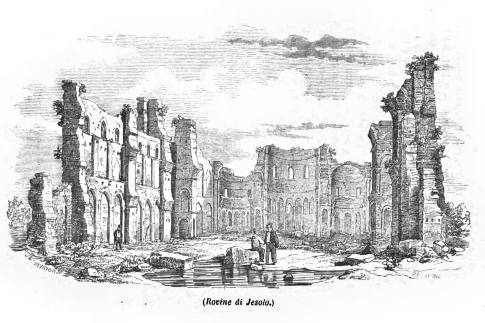
Further south, we have Fine, which might have been an island or a lido, and Heraclia (now Eraclea) which was definitely a lagoon island in the estuary of the river Piave, and Equilo (modern-day Jesolo), which was on a lido or just inside the lagoon, at the mouth of the river Piave.
Most of the unknown places mentioned by Porphyrogenitus were probably in the area around between Bibione and Jesolo, but as these 60–70km of lagoons have completely disappeared over the centuries, ancient islands and lidos have all but vanished from the landscape.
Heraclia was where the bishop of Opitergium moved around 640, and also the Byzantine Dux. It was therefore a significant place in the 600s and 700s, but was mostly abandoned later.
The river Piave changed course at some point, leaving the once island of Heraclia connected to the mainland, and therefore less easy to defend.
Fierce, and very violent competition between the neighbouring towns of Heraclia, with the Dux and the episcopal èseat of Opitergium, and Equilo (Jesolo), which was the local diocese, saw some of the early rulers of Venice killed, and the seat of the doge was moved south to Metamauco.
Later political, and again very violent, in-fighting in the dogado had the dominant elite from Metamauco raid and destroy Heraclia twice in the early 800s, from which it never recovered.
Its location was lost, and only rediscovered in modern times, after which the nearby village of Grisolera changed its name to Eraclea.
From Jesolo, the Venetian lagoon commences. In the marshes, the names of Lio Maggiore and Lio Piccolo still persist. In neither place is there anything medieval to see, but they’re both reachable by car, and the areas can give a good impression of how the early lagoon landscapes were — except for the cars, obviously.
Next is the group of Torcello, Ammiana, Constanziaca, Mazzorbo and Burano, some fifteen kilometres north of Venice.
Torcello is one of the most ancient settlements, from the same time as Heraclia, in the first half of the 600s. It was a major commercial centre, and where the bishop of Altinus moved. The cathedral of Torcello goes back to the 600s, and much of the current building is from the 800s. An inscription found there, indicated that the seat of the diocese of Altinus was moved there by permission of Isaac, Byzantine exarch of Ravenna during the reign of Heraclius.
The city was abandoned over two centuries, between the mid-1200s and the mid-1400s, as the harbour silted up, and malaria became a problem.
The neighbouring smaller towns of Ammiana, which was mentioned by some sources, and Constanziaca, were likewise abandoned, while the almost suburban settlements of Mazzorbo and Burano have survived until our time. This group of islands, all with people living there, might be what John the Deacon referred to, when he wrote that Torcello was protected by the surrounding islands.
Then we have the Lido Marcense —or the island of Sant’Erasmo, as it is called today. The island is like a countryside for modern Venice, but there is nothing medieval to see.
Finally, before Venice, there’s Murano, now famous for glass-works. The oldest building there is the Church of San Donato, which dates from the 1000s.
What we now call Venice, was in the early Middle Ages a marsh area, with a number of smaller settlements.
The most important of these gave its name to the wider area. The marketplace at Rivoalto — now Rialto — probably goes back as far as any other place in the lagoons. A higher ground — hence the name which means the high brink or shoreline — well protected by the surrounding marshes, at a bend of one of the main waterways in the lagoon — a branch of the Meduacus river, later called the Brenta — was a perfect location for commercial exchanges.
The other important settlement in the area was the fortified town on the island of Olivolo, in the easternmost part of modern Venice, with the church of San Pietro. When the area became a diocese of its own in 774, the seat was placed on the Olivolo island. In 1451, the diocese of Olivolo, or Castello, was merged with the Patriarchate of Grado, and then became the Patriarchate of Venice, which still exists.
Continuing south, we arrive at Poveglia, an island just inside the lagoon, which was an important settlement until the late 1300s. The settlement there persisted until the War of Chioggia in 1378–1382.
On the nearby lido, we have Malamocco, the probable location of ancient Metamauco. Metamauco was placed at the mouth of the Meduacus river, which further inland passed by Padua, a branch of which connected to the Rivoalto area.
When one of the early doges of Venice realised that Heraclia wasn’t safe, as his predecessor had been killed in a fight with the people of Equilo (Jesolo), he moved the seat of the duchy to Metamauco.
As Grado was the undisputed centre of church authority in the lagoons, Metamauco was the centre of political power in the Dogado for much of the 700s, until after the war with the Franks in 809, which we’ll talk about in a later episode. Metamauco was sacked and destroyed by the Franks, and the Venetians put up a new headquarters in the Rivoalto marshes, where the Doge’s Palace still stands today.
There is still a picturesque village at Malamocco, with some excellent fish restaurants, but nothing to see from the early Middle Ages.
The next town is Albiola, which probably coincided with a part of modern-day Alberoni on the southern end of the Lido di Venezia.
On the following island we have Pellestrina, still a small village of fishermen.
The next island, which is no longer an island, but connected to the mainland, we have Chioggia, which as a city goes back to Roman times, as Clodia. The larger part of Chioggia was on an island inside the lagoon, the Chioggia Majore from John the Deacon, while the Chioggia Minore was on a lido, where Sottomarina is now.
Just south of Chioggia, now a kind of suburb, but once a separate town, was Brondolo.
Finally, at the southern border of the Dogado, on the river Adige, we have Fossone near the estuary, the city of Loreo between the Adige and the Po rivers, and Cavarzere inland, once at the bottom of the lagoon, now on the Adige river.
Much more than Venice
This was the territory of the Dogado of the Venetians, from Grado to Cavarzere, made up of lidos, lagoons, marshes, wetlands and meadows, traversed by dozens of rivers, with a multitude of cities, towns and settlements.
Modern-day Venice was there, under another name, but it was still far from being the supreme centre of everything.
The church was based in the north, in Grado, with bishoprics in Caorle, Equilo, Heraclia, Torcello, Metamauco, and later, on the Olivolo.
The political centre of the dogado was initially Heraclia in the 600s, then Metamauco for much of the 700s, and only in the early 800s could Rivoalto claim the primacy of the Venetian cities.
Venice back then meant the state, the dogado, and for the first five or six hundred years of its existence, the city was called Rivoalto. It is only from the 1300s, that it became customary to use the name Venice for the city, and not for the dogado.
Related articles
- Early Venice
- Venetia et Histria
- The Lombard Invasion
- Did Narses invite the Lombards?
- The conquest of Venetia
- Venetian refugees
- The Medieval Landscape
- Invasions of Italy in Late Antiquity
- Chronology of the Lombard invasion
- Kings of the Lombards
- Exarchs of Ravenna
Venetian Stories
- Episode 3 — The Roman and Byzantine period
- Episode 27 — Cassiodorus
- Episode 28 — The early sources
- Episode 29 — The Lombard Invasion
- Episode 30 — Venetia Maritima
- Episode 31 — The world of Venetia
Related sources
- Main sources for early Venice
- The Historia Langobardorum by Paul the Deacon
- The Istoria Veneticorum by John the Deacon
- The Chronicon Altinate
- Liber Pontificalis — The Book of the Popes
- Pliny the Elder on Venetia
- De Administrando Imperio by Constantine VII Porphyrogenitus (c. 950)
- Translatio Marci Evangelistae Venetias (English)
- Translatio Marci Evangelistae Venetias (Latin)
Related images

Bibliography
- Bjornlie, Michael Shane. Politics and tradition between Rome, Ravenna and Constantinople : a study of Cassiodorus and the Variae, 527-554.. Cambridge, Cambridge university press, 2013. 🔗
- Gasparri, Stefano and Sauro Gelichi. Le isole del rifugio : Venezia prima di Venezia. Bari, Laterza, 2024. [more]
- Iohannes : Diaconus Venetus and Luigi Andrea Berto. Istoria Veneticorum. Bologna Zanichelli, 1999. [more] 🔗
- Monticolo, Giovanni. Cronache veneziane antichissime. Roma, Forzani e C. tipografi del Senato, 1890. [more] 🔗
- Paulus : Diaconus and William Dudley Foulke (translator). History of the Langobards. New York Longmans, Green & Co., 1907. [more] 🔗
- Paulus : Diaconus, Antonio Zanella (translator) and Bruno Luiselli. Storia dei longobardi. Milano BUR, 2000 (6th ed.). [more]
- Rossi, Antonio, Giovanni Galvani, Martino : da Canale and Emmanuele Antonio Cicogna. La Cronaca veneta detta Altinate di autore anonimo, in latino, preceduta da un commentario del prof. Antonio Rossi e La cronaca dei Veneziani del maestro Martino da Canale, nell'antico francese, colla corrispondente versione italiana del conte Giovanni Galvani e con annotazioni di Emmanuele Cicogna … [et al.]. Firenze : Gio. Pietro Vieusseux, 1845. [more] 🔗
Leave a Reply