The Venetian lagoon, as we know it, is just a small part of the lagoons which once were, both north and south of the estuary and delta of the River Po.
The current-day Venetian lagoon is about 50km long, but in the early Middle Ages, there were several lagoons with a combined length of over 130km, from Grado to Cavarzere, as the ancient Venetians liked to say.
The medieval lagoons were also wider, and with a much more varied landscape, than the lagoons we have today.
South of the Po river, there were many more lagoons.
The view from above
If we look at the territory of ancient Venetia from far above, inland it started in the foothills of the Dolomites, with a wide fertile plain sloping towards the sea. The coastal areas, where farmland gradually gave way to meadows and wetlands, and finally lagoons, were ultimately delimited by the lidos, which separated the lagoons from the open sea.
A number of rivers, of varying sizes, ran across this landscape. The main waterways were the Isonzo (Soça) in the north, then the Tagliamento, the Piave, the Bacchiglione, the Brenta, and the Adige to the south, but there were many smaller rivers, such as the Stella, Livenza, Zero, Sile, Dese and so on.
On a modern map, it is easy to see where the mainland ends and the lagoon starts, but it wasn’t always so. Rivers were diverted in the Middle Ages, dikes were built, and meadows and wetlands were drained and reclaimed to create arable land for farming.
In the early Middle Ages, there was a continuum of changing landscapes from the mountains to the sea. Hills gave way to plains, which gradually morphed into meadows, wetlands and lagoons.
There were few natural borders parallel to the coast, and as the territory was split on that axis between Lombard and Byzantine areas, drawing those borders was not easy.
An ice-age landscape
Below Venice, the lagoons, and much of Venetia, we find the marks of three ice-ages.
The bedrock under the lagoons is at a depth of some 900m.
Between the bedrock and the surface there are three ice-age deposits, each consisting of some 250-350m of sediments.
Europe, and in particular the Alpine regions, have gone through three ice-ages in the last quarter of a million years. Each ice-age lasted tens of thousands of years, and the last ended about twelve thousand years ago.
During each glacial period kilometre-thick ice-sheets covered the land and the mountains, When the climate then warmed, the ice melted, leading to abundant, fast-flowing rivers. The glaciers had ground down the mountains, producing copious quantities of sand and gravel, which the melt-water carried down towards the sea.
The sand and gravel transported by the melting water from the glaciers deposited along the way, in a layer which grew to several hundred meters in thickness as the ice-sheets slowly disappeared.
During the last ice-age, the location of Venice was some 500km inland, as the coast was then in the middle of what is now the Adriatic Sea.
When all the ice had melted, an interglacial age followed, which also lasted tens of thousands of years.
During these times, the rivers ran much slower, and only carried very fine sediment towards the sea. Over the many millennia, this sediment created a layer of dense clay, of some tens of metres in thickness.
Therefore, this having repeated three times, from the bedrock to the surface, there’s first a thick layer of sand and gravel from the ice-age some 150,000 years ago, then a thinner layer of clay from the interglacial age, then sand and gravel from the ice-age around 80,000 years ago, clay again, sand and gravel from the last ice-age, and finally clay deposited since the last ice-age.
Consequently, immediately under the surface of the entire territory of the wider Po valley, including the area of Venetia and the lagoons, there is a layer of clay, several tens of metres thick, made of an extremely fine sediment.
This is the clay Venice is built on, but it extends much, much wider than just Venice or the lagoon.
Because the sediment is so fine, the clay layer is effectively impervious to water. The dense clay is why the wooden pilings under Venice don’t rot, and also the basis for their ancient water supply, collecting rainwater in underground cisterns, separated from the salty groundwater by a barrier of dense clay.
Likewise, on the mainland, the layer of clay made the entire Po valley naturally swampy. Rainwater isn’t absorbed by the soil, so the upper layers saturate with water, creating swamps and wetlands.
The main problem of agriculture on the plains in northern Italy is therefore not a deficiency of water, but excess of water. When it rains, the water is not absorbed by the soil, but remains on the surface, forming lakes, swamps, meadows and wetlands.
Risotto is a traditional dish in the north-east of Italy, exactly because rice paddies are possible, thanks to the layer of clay just below the fertile soil.
Much of the Po valley, and surrounding areas, were therefore unhealthy and difficult to farm, mostly until the Romans arrived, and started systematic drainage works, but in some parts of the plains were only reclaimed in early modern times or even later. In other parts of Italy, such swamps were only reclaimed in the 1900s.
When some of the cities of Venetia appear to have been abandoned — such as Altinus — even if we have no record of a Lombard conquest, the reason might be environmental changes, which rendered the cities less viable.
A lack of maintenance of the drainage systems and control of the rivers, due to decades of wars and plague, caused territories, which had been arable and liveable for centuries, to return to their natural state as malaria infected swamps, meadows and wetlands.
The lagoons as a natural phenomenon
Finally, in this geographic survey of the landscape of Venetia, we have the lagoons and the lidos.
Why are there lagoons?
The defining element of the lagoons are the lidos. The lidos — from the Latin littus, meaning sandbank — are … wait for it … sandbanks.
They are created by a trick of nature.
The back and forth of the tidal flow in the upper Adriatic Sea, conditioned by the rotation of the globe, moves north on the eastern side, and south on the western side.
Consequently, the sea currents where the lagoons are, are consistently from the north to the south. The sediments carried by the rivers into the sea, are therefore deposited in long lines to the south of the estuary, drawn out by the dominant currents.
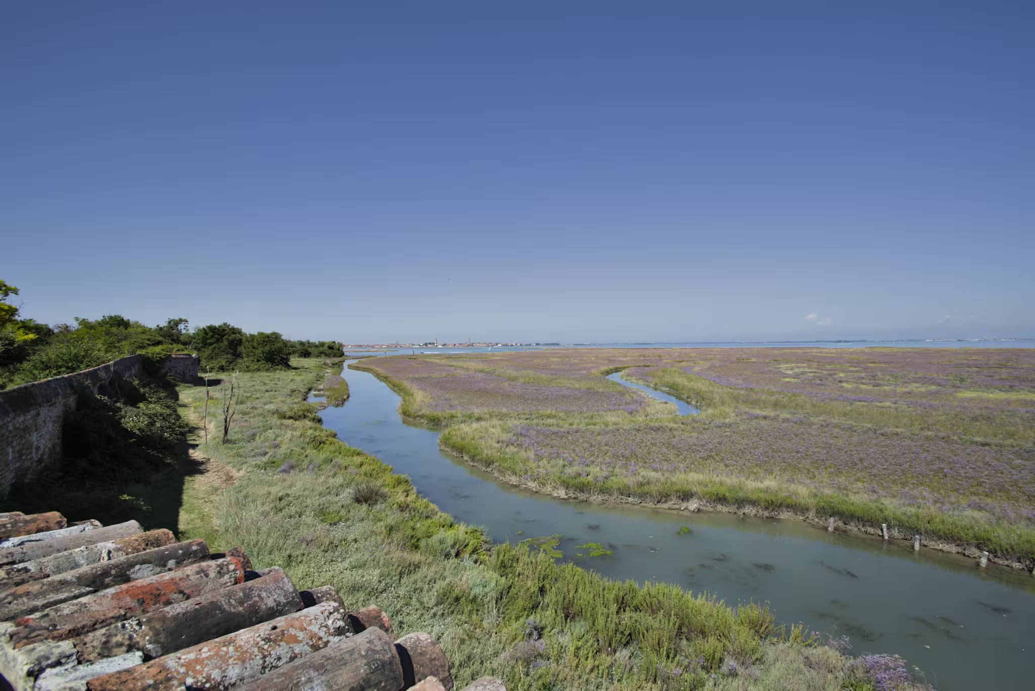
These long lines of sand are the lidos. As they form, they separate the sea from the area behind, which becomes a lagoon with an ecosystem, which is different and separate from that of the sea, and from the wetlands further in-land.
The lagoons — unlike the wetlands — are salt-water with a marked tide, but still distinct from the sea outside the lidos.
Such lagoons are inherently ephemeral. They will naturally disappear again. Once the lidos are formed, the rivers, no longer flowing directly into the sea, will deposit their sediments inside the lagoon, where they form a delta.
Gradually, the lagoon goes shallower, and more fresh-water, which leads to more extensive vegetation, and therefore higher rates of evaporation. The marshes dry out, and the lagoon is absorbed by the mainland, turning into freshwater wetlands, meadows and finally firm land.
At that point, the rivers flow into the sea again, and, if the sea further out isn’t too deep, a new lido can form, create a lagoon, and the whole process repeats.
This is part of the reason why many of the lagoons existing in the early Middle Ages are now gone, and also why the Venetians, between the 1300s and the 1500s, diverted many rivers. They had understood how the process worked, and wanted to keep their lagoon, as it was an essential part of their defences. Therefore, the rivers had to go around the lagoon, not into it.
The Venetian lagoon exists today thanks to the work done half a millennium ago.
Changing landscapes
The areas, where the Venetians from the mainland settled, were made up of wetlands, marshes, lagoons and lidos.
In the north, the territory started at the Isonzo (Soça) river, near Grado, and it extended to the Adige river in the south, just north of the Po river.
The lagoon environments continued to the south of the Po river, past Comacchio — where there’s still a large surviving inlet — and Ravenna until Cesenatico.
That area, however, was never part of Venetia, which was always north of the Po river.
The Venetian lagoons, from the Isonzo to the Adige, from Grado to Cavarzere, were continuous wetlands, unlike today.
A large central part — between the rivers Tagliamento and Piave — has almost entirely silted up, and is now a contiguous part of the mainland.
Likewise, the lagoon areas were much wider than they are today. Looking on a modern map, one can see how wide the southern part of the Lagoon of Venice still is.
The central and northern parts of the Venetian lagoon were equally wide, and that width extended all the way north and south, from Grado to Cavarzere.
In fact, Cavarzere — which, together with the town of Loreo, formed the southern border of the new Venetian lands — was a settlement on the inner side of the lagoons. It is now a mainland town, some ten to twelve kilometres from the coast, on the Adige river.
Diversions of the main rivers around the Venetian lagoon, and drainage works to turn marshes and wetlands into farmland, have dramatically reduced the width of the lagoon areas, along the entire coastline.
What we see today are just fragments of what existed in the early centuries of Venetian history.
The landscape of the early Venetians was therefore far larger than the lagoons we have today.
Their landscape was also, at the same time, both wetter and drier that what we have today.
Today, around Venice, one sees wide expanses of open water, interspersed with small, well-defined islands.
Twelve-hundred years ago, that view would have been of marshes, covered in low vegetation, which would be partially submerged at high tide, with a network of winding canals going here and there. Occasionally, there would be a wider open area, called a paludo, or a patch of land which was slightly higher, and partially forested.
The lagoon landscape was much more varied than it is today.
The rivers from the mainland wound their way through this landscape in a clearly visible way, wider and deeper than normal marsh canals. The Grand Canal in Venice, and the Canale Giudecca, are such ancient riverbeds, while most of the minor canals in Venice derive from the winding canals of the primordial marshlands.
Back then, there were far fewer open expanses of water, but overall the landscape was much more watery, but in the shape of marshes, wetlands and meadows, which in varying degrees flooded with the tidal cycle.
This was the natural world the Venetians went to live in, as they fled the Lombard invaders in the early 600s.
Leave a Reply